Wednesday 20 February 2013

DAY FORTY-TWO: STUNNING SOUTH ISLAND WESTLAND

Day 39 (Hokitika to Franz Josef Glacier) Daily Distance: 139.68 kms
Day 40 (Franz Josef Glacier to Fox Glacier) Daily Distance: 41.66 kms
Day 41 (Fox Glacier to Haast) Daily Distance: 135.73 kms
Day 42 (Haast to Makarora) Daily Distance: 81.90 kms
Total Distance: 2,461.07 kms

I started the morning in Hokitika with a ride to Sunset Peninsula where there are lovely views both west and south, and then a stroll along Hokitika Beach where there is a tonne of driftwood and so many lovely sculptures like these ones:
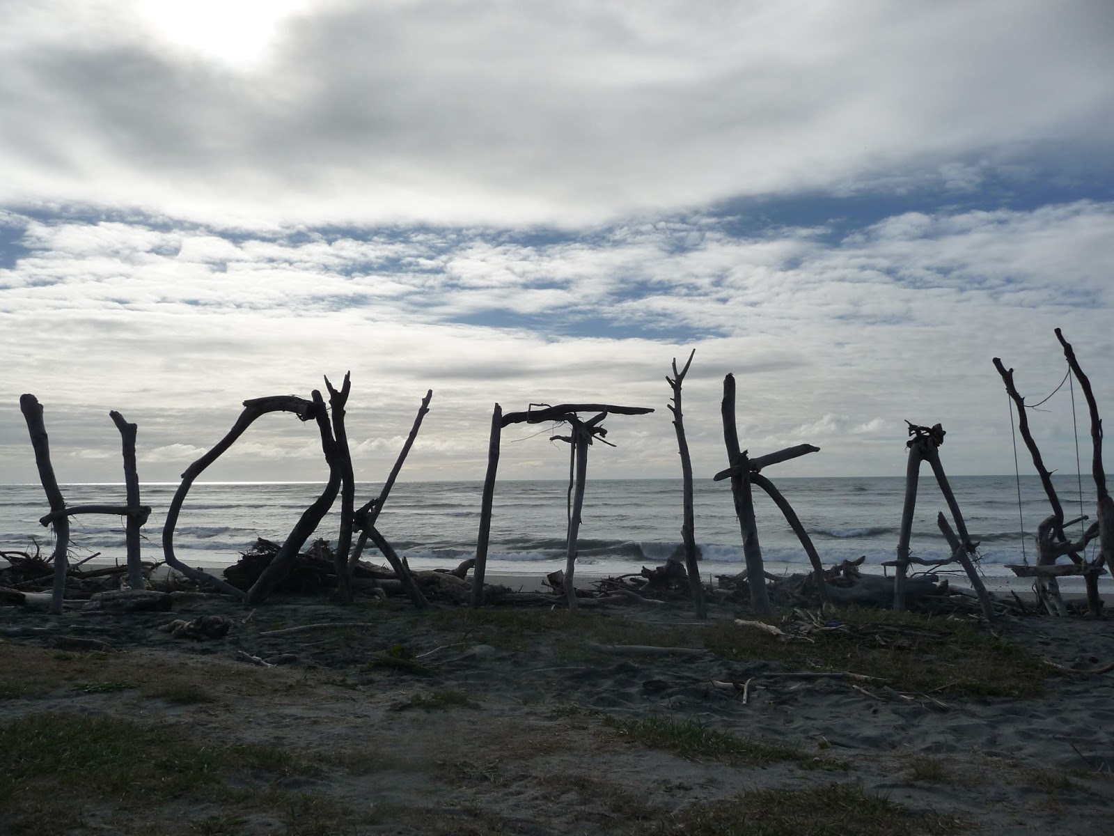
The local favourite is no doubt the name of the city spelt out, a sunset photo of which recently became the main welcome sign to the city.


This day would, by a small margin, become the longest of this trip so far, although it was a highly scenic ride which firstly saw me cruise pass a long beach that lay under bright blue skies and beside even brighter green fields, and then for the entire middle section of the day it was like riding through a huge rainforest, incredibly lush and dense but also keeping the wind away from me which I was thankful for.
I had coffee in Ross and lunch in Harihari before attacking Mt Hercules, which sounds much more threatening than it actually was. The only threatening moment of that climb was when a coach passed me extremely closely as it almost slowed to a stop – it was an AAT Kings coach and the Tour Director, Phil Wilson, had worked with me in Europe. He was waving to me madly as they passed and, bless him, was sitting on a plastic chair by the roadside in Franz Josef Glacier when I arrived many hours later. He handed me a beer before I even had the chance to say hi. What a guy!

Franz Josef is a relatively small but thriving tourist village with what seems like dozens and dozens of hotels, holiday parks and other accommodation options. The surrounding area is absolutely indescribably beautiful, with snow-capped mountains in several directions, although perhaps shamefully I never actually saw the glacier because it was off the beaten track and I’d heard it has receded so far that it was a much better option to go to Fox Glacier down the road.

I had planned a day off the following day but decided to do the short ride from Franz Josef Glacier to Fox Glacier because I’d heard it was quite demanding and the huge distance from Fox to Haast (with no towns or services in between) meant that it was by far the smarter starting point for cycling on Day Forty-One. Demanding was right – there were three huge hills to climb and descend, each of which was considerably more difficult than Mt Hercules!
Fox Glacier Village is smaller and less tourist-ridden than Franz Josef, and the ride to the glacier was definitely an unexpected highlight – a dedicated cycle trail through rainforest with lots of twists and turns. They’ve put lots of chicanes (i.e. huge boulders) in the path to stop crazy cyclists from me from going too fast, but they failed because I was going much too fast along the trail. It was impossible not to.

I walked the last 20 minutes to the actual glacier and got within 100m of it. It’s fascinating actually seeing the glacier fall apart in front of your eyes. It’s big and blue and sort of beautiful, but also dirty and with lots of tourists walking all of it (each of who paid at least $120 for the pleasure!)
Fox Glacier
That afternoon I met a couple from Switzerland who are cycling around the world and having spent the last 24 months riding through Europe, the Middle East, Asia, Australia and some of New Zealand, they have just cracked the 42,000km mark!!! I was speechless. When finished, I will have covered just 6,500km in both of my tours combined. (To give you an idea of how crazy they are, in Australia they cycled from Perth up the west coast to Katherine and then Darwin, then down the country past Uluru to Adelaide, and around the coast to Melbourne, Sydney and Brisbane where they flew to Christchurch…)

Klemens & Brigitte from Switzerland

I woke at 7am on Day Forty-One to enable me to ride the 12km round trip to Lake Matheson before departing for Haast. This lake is famous for providing beautiful reflections of Mt Cook on its surface, but unfortunately the clouds were hanging around when I was there. It was still stunning.
Lake Matheson
After that trip I continued south, passing another couple who are nearly finished their round the world cycling trip (this pair, from NZ, have only covered 19,000km. Pfft!). I stopped at a salmon farm for lunch – don’t worry, I didn’t eat salmon – and then passed more spectacular scenery on the way to Haast where the steep Haast Pass awaited me the following day.

The climb through the Haast Pass was certainly no cake-walk, but it was nothing like Arthurs Pass as it only rose to 540m rather than 960m. In addition, I seemingly had half of the worlds touring cyclists to do it with - I have seen more tourers in the past two days than in the rest of the country combined. A Taiwanese kid who'd broken his gear cable and was struggling to ride, a middle-aged man from Colorado, two Australian women from Melbourne, a Kiwi couple, Peter from Toronto, Gemma from England (who with her friend Izzy I had run into twice up near Rotorua!) who was stranded in Haast with a broken spoke, two English guys who are following their cricket team around, and the list goes on...

The area around Haast is apparently the wettest in the country with an average rainfall of 400 inches a year (!) but again I seemed blessed as there was nothing but blue skies and a bright, hot sun. I stopped to do a few side walks, the best being down to Blue Pools which were very cold but stunningly clear and blue, as the name would suggest.
 
Blue Pools
I camped in Makarora, having completed the stunning South Island West Coast and with just the beautiful Wanaka, Hawea and Wakatipu Lakes – and the huge Southern Alps – in front of me en route to Bluff.

Saturday 16 February 2013

DAY THIRTY-EIGHT: MAKING UP FOR LOST TIME

Day 34 (Blenheim to Kaikoura) Daily Distance: 132.37 kms
Day 35 (Kaikoura to Greta Valley) Daily Distance: 107.47 kms
Day 36 (Greta Valley to Springfield) Daily Distance: 126.94 kms
Day 37 (Springfield to Arthurs Pass) Daily Distance: 86.82 kms
Day 38 (Arthurs Pass to Hokitika) Daily Distance: 101.91 kms
Total Distance: 2,062.10 kms

We’d planned to leave Blenheim quite early to accommodate for the long day, but with some members of LSR being even less punctual than me (hard to believe, I know) it never happened. So at 11 o’clock we trundled out of town and after the first big hill the trundle soon escalated into a gallop and then perhaps a race. We averaged nearly 28 km/hr for the whole 132 km day, a personal record of some sort no doubt, and despite several stops (including one at the lovely yet lonely café 'The Store') we still arrived into Kaikoura with plenty of time to relax, shower and wander into town for a meal.
Views on the ride into and out of Kaikoura looked much like this...
(Ed: I realise previously neglecting to explain why we ended up in Blenheim heading down the east coast of the south island rather than the west coast as I’d planned. Since I’d diverted to Golden Bay and lost two days on my schedule and, in the meantime, booked my flight back to Oz on March 1st, I had to make up those days. To do this, I decided to head down the east coast to Christchurch and then catch the TransAlpine Train to Greymouth and head down the west coast from there.)

The next day the four boys decided to have a restful day with the whales and seals of Kaikoura, but my new, tight schedule didn’t allow such luxuries, so I fought a huge headwind down to Greta Valley. I was supposed to meet Canadians Joanna and Kyle there, but they didn’t make it because of that headwind, although I did have the company of six retired Californians who I crossed paths with several times.
One of many seal colonies near Kaikoura
There was much less in the way of shops than I’d anticipated (in fact not a single shop, petrol station or pub for the first 65 kms, and not a thing open when I arrived in Greta Valley at 5pm), so it was a makeshift meal for dinner that night. I stayed in a campervan that the campsite owner kindly gave me for just $12 (the price of a tent site) given the chance of rain overnight. By “gave” I of course mean “leased”, although given its age and grubbiness, it couldn't have been sold for much more than $12, I think. It was nice gesture all the same, even though the rain never came – as seems to have been a common theme since north of Auckland when I last felt a drop (it poured in Wellington but I was off the bike on those days).

Kaikoura whale watching cruise
The next day I intended taking an easy route into Christchurch before catching the train the following day, but at some stage that morning I convinced myself to ride across the island rather than catching the train. There were two reasons for this: a) I thought it might be considered cheating (even though Greymouth is some 65 kms north of Christchurch) and b) I did the famous train ride with Dad back in 1999(ish). So I never made it to Christchurch, but cut inland and turned it into another 100k+ day to arrive in Springfield, the last town before Arthurs Pass.

The following day, Thirty-Seven, I continued west aiming for Arthurs Pass Village, the only real town of note in the National Park, which is located just a few kilometres short of Arthurs Pass itself. The village and pass are called as such because in the 1860’s Arthur Dobson was asked to survey the valley by his employer and later, when £200 was offered to whoever could find the best route from Christchurch to the West Coast and vice versa (important because gold was being mined on the west coast and had to be transported to Christchurch), his Dad - also in the same surveying business - correctly reported that “Arthur’s Pass” was by far the most suitable.

Well, Arthur must have been a fit fellow – or someone with lots of time on his hands – because it was one heck of a climb! In the world of cycling, climbs are only ‘rated’ if they are 500m or longer, with an average gradient of 3.0% or more. There are six categories (the hardest is ‘HC’ which stands for French “Hors Categorie” = “above category”, then Cat1 to Cat5). 12 kilometres into the day I met a Cat2 climb, and we had 6.2 kilometres to get to know each other. Needless to say we didn't become best friends... to say it was a beast would be an understatement, with its average gradient of 5.4% and maximum gradient of – wait for it – 17.2% … cars were struggling to get up this thing! This was followed by one Cat4 and six Cat5 climbs throughout the day. In total I climbed 1,631m over just 87 kms. Enough said.
But there were moments of relief among the climbs, notably the beautiful Lake Pearson and the crazy rock formations around Castle Hill, which in 2005 was used as the set for Chronicles of Narnia, but presumably of greater importance was said by the Dalai Lama in 2002 to be "the spiritual centre of the Universe".


Leaving Arthurs Pass was another highlight of the trip. I knew that I’d have one steep, long climb to get from the village to the top of the pass, but I didn’t know just how stunning the scenery would be descending from there. I dropped from nearly 1,000m altitude to near enough 0m in the course of the day, what a delight! It was also the first day that I really got cold on the bike, but I do think that the high winds and gloomy weather played as big a part in that as the lack of pedalling.
First sighting of the famous Southern West Coast Alps
I had lunch in Kumara, one of the towns where the previously mentioned gold rush occurred, and once I hit the west coast turned south to be greeted by a howling southerly wind which drastically slowed me down for the last 30 km. I eventually limped into NZ capital of jade Hokitika and loaded up with carbs again in an attempt to recover from a truly testing five days, four of which exceeded 100 kms, with the fifth being the Arthurs Pass day. At least I made up previously lost time and it left me well and truly ahead of my new schedule.

Tuesday 12 February 2013

DAY THIRTY-THREE: HANGING OUT NORTH OF THE NORTH ISLAND, ON THE SOUTH ISLAND…

Day 30 (Wellington to Mouteka, via Picton)
Day 31 (Mouteka to Takaka)
Day 32 (Takaka to Picton)
Day 33 (Picton to Blenheim) Daily Distance: 58.65 kms
Total Distance: 1506.59 kms

The plan had been to catch the ferry from Wellington (at the southern tip of the North Island) to Picton (at the northern tip of the South Island), and then immediately head west towards Nelson and straight down the west coast, but that plan was thrown into disarray when LSR managed to convince me to jump in their rental car as soon as we arrived in Picton and have a few days off the bike – ‘coz I haven’t done that lately!
Apart from the fact that I’m rubber-armed and terribly indecisive in any case, I’m on holidays so why not?

Also rubber-armed were Tourers #13 and #14, Canadians Joanna and Kyle, who a few years back rode all the way across CANADA! 5,000 kms I think they said, crazy. I met them on the ferry and after bonding over our shared Tip to Toe itinerary and shared homeland (sort of), they were somehow also convinced to hire a second car to join our party, heading north from Picton towards Golden Bay.

Readers who failed ‘Geography of New Zealand’ at school (and probably even those who didn’t) will now be confused as to how you can go north from a city that is at the northern tip of an island. And it probably won’t help if I throw in more geographical detail: Wellington and Picton lie at the same latitude. As in, they are each as far north, or south, as each other.

Confusing, isn’t it?

So technically, I had just sailed south to a city north of where I started, on the northern tip of a ‘south’ island, only to jump in a car and drive north of there to a place far further north than the north island city I originally began in before the ferry. Well, you should know by now that everything in this country is backwards, upside down, or just bizarre.

I’ll wait while you go and find a map.


We drove around Queen Charlotte Sound and through Nelson to Mouteka with the intention of kayaking along the coastline of Abel Tasman National Park the following day. We were presented with no less than 10 options for kayaking, all with different start points, end points, durations, inclusions, costs etc, and so did what any normal people would do: none of them. Instead, we drove our car to Kaiteriteri Beach, supposedly one of the “top 5 beaches in the world” (no), and then to Split Apple Beach, not supposedly one of the “top 5 beaches in the world” (although we think it could be). It was fantastic.

L-R: Brian, Lex, Parri, Mark, Devin

After a stunning, if stomach-churning, drive across mountains I wouldn’t dare touch with two wheels, we found ourselves in Takaka, the first and biggest town in Golden Bay.


We visited Pupu springs, with its fresh water that is apparently the clearest in the world – a grand claim but it did look pretty clear – and then set up camp before embarking on what would be the best night of my trip (or LSRs) to-date. To summarise: Brian got on stage to sing and play guitar in between sets of the band that was actually supposed to be on stage, and even dedicated two songs to me!
Devin went crazy with a dance routine that, believe it or not, included toe-tapping, break dancing, push ups, foot-stomping and older-lady-spinning within 30 seconds of each other.

Lex had a random drunk girl come up and randomly start cuddling him. Or rather, cuddling his lap. It was slightly awkward.
Mark befriended all the locals, and somehow ended up being convinced that LSR should join me on the west coast once the riding resumed since “the east coast is boring”.

And a local kid bought me a beer in exchange for a ‘ride’ on my shoulders while we danced on the dance floor. He could have died. (Which would have been controversial since he was only 17 and so not even legally allowed in there – the bar manager knew, but it was a small town so she clearly didn’t care because she sold him drinks. Maybe it was her brother? After all, her Mum was the older lady that Devin was dancing with. No, she seriously was.)
And this was all after we met some fun and chilled-out hippies (I’m sure that they would also choose that word to describe them) in the middle of the local library car park where we drank beers and sang along to two ukuleles. One of these was an English guy who is currently renovating his boat and needs four people to help him sail it to Australia, hmmm…..

Unfortunately the next day we had to head back to Picton to return the car AND to make sure that we started riding from there so as not to invalidate any north-to-south cycling claims. We stayed in Picton that night so that I could watch Australia reach 4-0 over the Windies in cricket, and the boys could edit and post their third update video (you can see it here, although Mum please note they have somehow captured me on video the only two times on this trip that I have said a swear word).
The next day we only had 35 kms to ride to Blenheim, but we decided to stretch that out to 58 kms so that it could include some of the famous Marlborough wineries, a chocolate factory, a fudge factory, and two punctures for Lex. There was a huge food and wine festival on in town that night, so we joined the revellers in the street party until we realised that the next day was to be a three-digit-km day on the bike.
 

DAY TWENTY-NINE: NZ NORTH ISLAND BY BIKE? CHECK.

Day 26 (Wanganui to Himitangi) Daily Distance: 76.06 kms
Day 27 (Himitangi to Wellington) Daily Distance: 139.42 kms
Days 28-29 (Wellington Rest Days)
Total Distance: 1447.94 kms

I didn’t have far to travel on Day Twenty-Six so I had a leisurely Saturday morning in town. There were some local markets by the river, I met some giant pencils (still not sure why they were there?) and went up New Zealand’s only underground elevator to a lookout over the river we’d canoed as well as Wanganui town itself.

Even though I’m impressed that the elevator was built to develop the suburb of Durie Hill way back in 1919 and still works, I still found it underwhelming. The pencils were more exciting.

The ride that day was uninspiring given the scenery didn’t much deviate from flat hot farmland, although I did get to ride through a place called Bulls, a town like no udder. That night I was hosted in Himitangi (just outside Palmerston North on the Foxton side) by Gerald and Sue Turk, Monique’s Uncle and Aunt who I had met at the wedding when they kindly invited me to stay. I had a full guided tour of their free-range poultry farm, and it was extremely interesting to see how one farm can manage 135,000 chickens at a time!


Given that it was a Saturday night, I joined Sue and Gerald at their ‘local’ with the whole family – the only two properties that separate theirs and the pub are home to their two daughters and their respective families – good planning I say! It brought back so many memories seeing a huge group of kids, six of which were Sue and Gerald’s grandchildren, roam free and unsupervised (not in an irresponsible way, in a country town sort of way) as they ran around the huge yard having water fights and playing rugby and jumping fences and falling over and doing things that I did when I was little and too few iKids seem to do these days…
In terms of distance, the next day was the longest of either of my touring trips so far, but conditions obliged and I got it done in reasonable time – a tick under six hours of actual riding time – even though I stopped to pick over half a kilogram of blueberries … which only cost me five bucks!

On arrival into Wellington I rode past the workplace and apartments that housed me when I was sent here for work back in 2007, and also got to Kelburn where James lived and where the top of the famous cable car is found.

Given I’d seen much of the city back in ‘07, it was a relaxing couple of days, although I did re-visit Te Papa, NZ’s National Museum, stroll along the waterfront and reunite with LSR. It was as windy as I remembered.
So with that it was NZ North Island: check.

Friday 8 February 2013

DAY TWENTY-FIVE: TAKING THE CYCLE OUT OF CYCLE TOURING

Day 21 (Tongariro Alpine Crossing)
Day 22 (National Park to John Coull) Daily Distance: 44.50 kms (canoe)
Day 23 (John Coull to Tieke) Daily Distance: 27.50 kms (canoe)
Day 24 (Tieke to Wanganui) Daily Distance: 97.06 kms (22 km canoe; 75.06 km cycle)
Day 25 (Wanganui Rest Day)
Total Distance: 1,232.46 kms

 “Tongariro National Park is New Zealand's oldest national park and a dual World Heritage Site ... it ranks among the top ten single-day treks in the world."
--TongariroCrossing.org.nz
 
"Reputedly the best one-day walk in NZ, the Tongariro Alpine Crossing traverses spectacular volcanic geography, from an active crater to steaming vents and beautiful coloured lakes."
-- Lonely Planet

These quotes really say it all.
And so does this.
The Te Mari crater erupted in November 2012 meaning that the second half of the crossing is currently closed (grumbles are still heard almost every day), but it was still possible to do the first half of the crossing and then return to the beginning, while apparently still seeing all of the highlights.

A quick walking pace meant that we had a bit of extra time, so we took a side trip up to the top of Mt Ngauruhoe, also known as Mt Doom from Lord of the Rings. It was a steep 45◦ climb with no track and little to get a solid footing on, meaning that we had to scramble up on a thick layer of loose volcanic ash as it slipped down the mountain, with every step forward being followed by big slide backwards. The views from the top, however, made this more than worthwhile:
 

Coming down the mountain was equally challenging – it was literally a case of skiing down (but on scree rather than snow) as each step created a mini avalanche down the mountain on which you could ride for three to four metres. Good fun, although given this is a National Park, it made me feel bad, and left me wondering how long the mountain will exist if people like me do that hike each day.

This was all done with Fast Rene, named as such because he is constantly amazed at how slow everyone else rides (and lives life in general), and Left Side Ride (LSR), who now deserve proper introductions given that they have suddenly become central characters in this Kiwi adventure of mine.
LSR is made up of Brian, Mark, Devin and Lex, four Americans who worked together in Event Marketing which saw them travel across their entire country representing different companies at events like Nascar, the PGA Golf tour and Army recruitment drives. Like my most recent job, this provided them a varied, exciting workplace and allowed them the freedom to travel, have amazing experiences and meet lots of new friends. Also like me, though, this didn’t afford them the chance for a settled lifestyle so they decided to quit their jobs and cross the globe … with their bikes. After NZ they are continuing their adventure through Australia, Indonesia and Thailand. You can follow them at www.facebook.com/LeftSideRide.

There were two pick-up times to take us back to the hostel, and sure enough after running in the hot sun for 30 minutes, we arrived about 4 minutes after the first bus left, leaving us waiting for an hour and a half for the second. It reminded me a lot of missing a certain boat some months ago.

On recommendation, I’d wanted to do a small section of the Tip to Toe journey on the Whanganui river by canoe, and after all the cycling and hiking my legs needed a break anyway. Both Rene and the LSR boys expressed interest in joining me on this leg of the journey, so at last minute we managed to organise ourselves and we started the following day.


 The canoeing was absolutely spectacular – deep in a fern-lined canyon with waterfalls and wildlife everywhere but humans not so, the scenery was equally stunning for every one of the 88kms that we travelled. It never got old.
 
We camped on both nights, and being on ancient Maori land that has recently been under dispute, the second night we were invited into a local marais for a pōwhiri (welcome ceremony) to learn about the Maori culture. Local Maori leaders Wai and Munaki were very welcoming and invited us for breakfast before he officially farewell us from their land with the blowing of a ‘pukaea’ (Maori trumpet).

We were all mauled by sand flies, Lex and Devin managed to fill their canoe with water after hitting a huge rock during one of the larger rapids, and we were late for the pick-up, but otherwise we managed to stay out of trouble.
 
On arrival in Pipiriki we were met by the canoeing staff who swapped our bikes for their canoes before sending us on our way. Less than 5 minutes into the ride to Wanganui Rene and I managed to lose the entire LSR team, so continued on ourselves via the scenic river road on one of the official NZ Cycle Trails, arriving in Wanganui 76km later at 9.30pm. LSR, in the meantime, chose a less direct route on which they apparently endured a horrid 28km climb, and then a 100km ride the next day, arriving in Wanganui about 24 hours after Rene and I. They were sorry to have missed a trick on this occasion but glad that they survived to tell the tale.

Having not showered or washed clothes in days, I took the opportunity to freshen up in Wanganui before the final push to the bottom of the north island. That, and I had to re-learn how to ride a bike after taking the cycle out of cycle touring.


Sunday 3 February 2013

DAY NINETEEN: LAZY LAKES

Day 16 (Mount Maunganui to Rotorua) Daily Distance: 71.09 kms
D
ay 17 (Rotorua Rest Day)
Day 18 (Rotorua to Taupo) Daily Distance: 101.71 kms
Day 19 (Taupo Rest Day)
Day 20 (Taupo to National Park Village): Daily Distance: 113.65 kms
Total Distance: 1063.40 kms

During an early stop in Tauranga, I’d been told to expect some hills in between there and Rotorua, and sure enough they came in the form of two deep gorges. It was tough climbing out of these as my cycle computer ever so slowly ticked from 3.94 to 3.95 to 3.96 (and seemingly back to 3.95 as I rolled backwards...). It made me wish that I’d left OUT of my panniers the laptop, extra bike lock, jumper, two books, and in fact just about everything bar the vasoline, water and mobile phone (in case I didn’t make it). Once I conquered these, though, there was a nice long descent down to Lake Rotorua during which I almost coasted with no work required for 15 or so k’s. It was a lazy entry to the city bearing the same name.

I’ve been to Rotorua previously (with my friend Craig in 2007 when I was based in Wellington for work) and did Zorbing on that occasion, so on my full day in Rotorua while I did contemplate the long list of extreme activities offered, I settled for something more scenic in the skyline gondola to the top of Mt Ngongotaha and five luge runs back down the tracks.

Skyline Rotorua Luge
There were some very cool night markets in the city that night with an array of amazing food, quirky gifts (that I admired but didn’t purchase given the lack of room in my bags), and even live music. Even better, the city didn’t smell nearly as much as I’d remembered it did from my previous visit.

Leaving Rotorua the next day, I noticed a new, flat, bright white paved path immediately next to the motorway and considered crossing onto it for the first 20 minutes but didn’t, for fear that it would veer off and suddenly leave me heading in the wrong direction and with no easy way of re-joining the main road. Eventually, however, I saw a sign indicating that it was 'Te Ara Ahi', the Thermal By Bike Trail, so jumped onto it  - at which time the new, flat, bright white paved path of course promptly ended - and followed it down to Kerosene Creek on a trail that took a toll on both my body and bike: it was worth it when I bathed in the hot river for an hour.

One problem with New Zealand’s National Cycleway is it’s designers seem to have no appreciation for the vast difference between road, touring and mountain bikes given the trails are apparently targeting the former, but include terrain appropriate for only the latter on occasion,  as in this case when I was left riding for half an hour through a very nice, very scenic path – but one totally inappropriate for poor Javier.)
I then passed Wai-O-Tapu Thermal Wonderland which, as I understand, is an attraction very similar to the aforementioned but one full of tourists and with a hefty entry fee, so decided I’d had enough bathing for one day.

I passed an enormous bike that may even have been too big for me…

And then I passed two English girls riding from Auckland to Christchurch who I’d actually met in Paeroa several days earlier, bringing my total of fellow Kiwi-touring cyclists to 11 (4 x American Left Side Riders, 2 x French couple, 1 x German life-cyclist, 1 x French guy, 2 x English girls, 1 x unknown guy way back at Cape Reinga, and I think that’s it…).

Speaking on running into fellow tourers, as soon as I arrived at the hostel in Rotorua, I ran into Left Side Ride (LSR), who I’d not seen since Paihia despite good intentions on both parts to do so. Like me, they’ve made slower progress than anticipated, but not really because of hard days riding, more so just enjoying the scenery and regular breaks more often, plus the added burden they have of shooting truckloads of footage on their array of equipment – albeit minus one camera that has since been lost – and then trawling through the footage to find the good stuff and turn it into short clips for their followers. (You should check out their summary clips for Week 1, and Week 2 -- great viewing!)
Day Nineteen happened to be Australia Day so I decided to have another day off to relax and enjoy it. What I didn’t expect was that I would jump off a 47m high platform with only a rope attached to my ankles, but that’s exactly what happened when two members of LSR decided to go Bungy Jumping and on arrival I decided that I didn’t want to miss out ... and that it was a good way to celebrate my national day.

 
Following that, we headed to some free natural thermal pools which were boiling hot – not what was needed on such a hot day - and then I explored the town and the lake before celebrating with a whole lot of Aussies who came out of the woods that Saturday night in Taupo. LSR departed that afternoon to get to Turangi, halfway to National Park Village, since it was a big ask to make it there in just one day as we’d all initially intended. I, on the other hand, had my second lazy rest day by a lake in just three days.
I left early on Day Twenty as I knew it was going to be a long day with a fair bit of climbing, and given LSRs total inability to ever depart before midday, deep down I knew that I was a good chance of making it to Turangi before they even left. Sure enough, I did run into them en route, aided by an extremely quick first 50 kms out of Taupo on quiet, descending roads with spectacular lake views the whole way. One descent even helped me cross the 70 kmph mark, a new record on either of my touring journeys.

But meeting them on the road was more of a fluke than I’d anticipated since we had actually taken separate routes out of Turangi – I had been advised by tourist information to take a route 5 or 10 kilometres longer than the main road, but significantly easier by bike given it’s gradual climb compared to the steep hike faced on the main road. LSR had unfortunately missed this advice and so were well tired by the time I met them at their milkshake stop.

It was here that I met fellow tourer #12 and soon to be famous character in this adventure: 'Fast Rene'. He is a 24 year old Dutchman who came on holidays to New Zealand not expecting to do any cycling, but inspired by a girl he met in Auckland who had a cycling journey planned, he purchased all the gear and, with a suffocating budget began his trek across the country. He had run into LSR several days earlier and then again near Turangi, so the six of us continued together to National Park Village, which pushed me past the 1,000 km mark for my Tip to Toe adventure.
That night I bought Rene a bottle of wine so he could have some drinks with us without breaking his budget, although I should have just given him the one that I consumed as, along with the rest of the drinks we downed (it was Aussie Open Final night after all) it turned into a rather large one. Not so bad if you don’t have planned one of the most beautiful (and physically demanding) hikes for the next day... but we did.

If only the next day was to be another by a lazy lake.